
Johns Hopkins UniversityEst. 1876
America’s First Research University
Now Browsing:
Four places to visit in Maryland this August
Planning your weekend excursions for the month of August? Author Bryan MacKay has the inspiration you need. The following is excerpted from his book, A Year Across Maryland: A Week-by-Week Guide to Discovering Nature in the Chesapeake Region.
Dolly Sods Wilderness, West Virginia
54 miles south of Oakland, Maryland (Garrett County); 20 miles west of Petersburg, West Virginia (Grant County)
What to see and do: The “dog days” of August are here, and as we sweat in the hot humid air, our thoughts turn to a weekend
getaway in cooler climes. No location in the mid-Atlantic region is reliably cooler than the Dolly Sods Wilderness, located in West Virginia a few dozen miles south of the southernmost tip of Garrett County, Maryland. Even in midsummer, temperatures at Dolly Sods can drop into the forties when the occasional wedge of Arctic air reaches the mid-Atlantic, and high temperatures rarely exceed eighty. A high ridgetop plateau, the land- scape at Dolly Sods resembles that of the Canadian sub-Arctic, with stunted, wind-flagged trees and extensive tundra-like open areas. The vegetation is dominated by species typical of land far to our north; it includes rhododendron, bracken fern, cranberry, reindeer moss, sphagnum moss, hemlock, and red spruce. It’s a long drive from Washington, D.C., or Baltimore (more than four hours), but Dolly Sods offers a worthy and welcome oasis from midsummer heat and humidity and is a fine destination for camping, hiking, and backpacking.
Naturalist’s tip: By late summer and into fall, there are always berries ripe for snacking among the plants of the open tundra, including blueberries, huckleberries, and cranberries.
More information: For a description of hiking trails at the Dolly Sods Wilderness, see www.midatlantichikes.com.
Gunpowder Falls State Park below Prettyboy Dam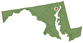
18 miles north of Towson (Baltimore County)
What to see and do: The coolest place in central Maryland in mid-August is the river valley of the Big Gunpowder Falls below Prettyboy Dam, where water released from the dam refrigerates the narrow gorge. For a pleasant hike along the river under big trees, park at Masemore Road and walk upstream along the white-blazed Gunpowder South Trail. It’s about three miles
to the base of the dam. Just north of Falls Road is a stretch of river reminiscent of far western Maryland, as the gin-clear river dances over steep rapids among room-sized boulders and hill- sides of mountain laurel. If there is sufficient flow, launch your canoe or kayak from Masemore Road and venture downstream eight miles to Monkton Road through the mature forests of Gunpowder Falls State Park.
Naturalist’s tip: The three-mile stretch of river from Masemore Road to the dam is the premier easily accessible fly-fishing venue in the mid-Atlantic region. The parking lot at Falls Road usually holds cars from at least three states. The north-facing hillsides have extensive stands of mountain laurel that bloom for a week or so in late May.
More information: Visit www.dnr.state.md.us/publiclands/central
/gunpowder.asp.
more aware of this nettlesome plant on future hikes.
Potomac River float trip and a visit to Dam Number Four Cave, C&O Canal National Historical Park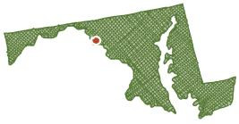
12 miles south of Hagerstown (Washington County); 8 miles northwest of Antietam National Battlefield
What to see and do: What better way to relax on a hot
late-summer day than floating a few miles down a quiet river, with a stop to explore a cool walk-in cave? Launch your canoe, kayak, raft, tube, or air mattress just below Dam Number Four on the Potomac River in Washington County. Wearing your personal floatation device, you can slip overboard to swim or float along with the slight current to enjoy the clear warm water of late summer. Stop at riffles and ledges to look for clams and snails, or to wet a line, and have lunch under the shade of big riverside silver maples. One mile downriver from Dam Number Four is the mouth of a walk-in cave. It is visible from the C&O Canal towpath if you are walking but requires foreknowledge of where to stop if you are on the river. The accessible portion of Dam Number Four Cave is always at least four feet high, generally only slightly muddy, and runs straight for about a hundred feet, illuminated faintly by sunlight. Bring a flashlight to explore the final several dozen feet, which are in total darkness. Returning to the river, continue drifting down to Taylor’s Landing, finishing a slow-paced three-mile float of a relaxing, satisfying river. Hike back to your car on the towpath, or set up a car shuttle before starting the trip.
Naturalist’s tip: Look for cave crickets, long-tailed salamanders, and bats in the many nooks and crannies of Dam Number Four Cave (but please do not disturb).
More information: Visit the C&O Canal National Historical Park website at www.nps.gov/choh/index.htm.
Assateague Island National Seashore, Maryland and Virginia
9 miles south of Ocean City (Worcester County)
What to see and do: There is something about the late-summer ocean beach: a wistfulness that comes from knowing the sea- son is shifting, that it has in fact almost imperceptibly turned toward autumn. Assateague is a wonderful place to visit at any time of the year, but these last days of August seem especially pleasant, a time to treasure the final bloom of a fading summer. To experience the full character of this barrier island, camp among the dunes at the National Seashore where you can enjoy the magical hours of sunrise and sunset, and walk the ocean beach under the stars.
Naturalist’s tip: In summer, biting insects at Assateague can be maddening. They seem worst about five days after a good rain that provides pools of standing water. The best time to visit is after a long dry spell. You can almost always get away from biting insects at the ocean’s edge.
More information: Visit www.nps.gov/asis/index.htm
Login to View & Leave Comments
The People of Rose Hill: Black and White Life on a Maryland Plantation
By Lucy MaddoxFor anyone who sets out to write a history, the result of finishing such a project has to include a sense of incompleteness. There’s much the writer simply cannot know, but there’s also much the writer can’t include because it’s not sufficiently...

Wildlife Management and Landscapes
The late William “Bill” Porter, one of the editors of Wildlife Management and Landscapes (WML), was a fan of making up adages to lighten the mood in complex ecological discussions with his students. One of my favorites was, “Ecology isn’t rocket science… it’s...

The Painted Poem
Measuring only 5 ½ x 9 7/16 inches, Giovanni Boldini’s 1879 painting Return of the Fishing Boats, Étretat, has long been one of my favorites at The Clark Art Institute in Williamstown, MA. Indeed, there are far greater paintings by Monet, Renoir, Degas, and...

Login to View & Leave Comments